|
Area Hiking Trails

|
Village Gramos - Gistova alpine lake (3 hours) - Peak 2.520 (+2 hours) - Perifano Peak (+2.5 hours)- village Gramos or Aetomilitsa.
|
|
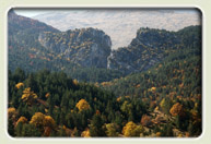
The marked trail starts from the village Gramos at
approximately 1,400 meters altitude and climbs in a western
direction through the Gramos alpine meadows towards lake
Gistova at 2,350 meters, just below the Gramos ridge. From
there, a mild marked trail going south will take you in two hours
to the peak at 2.520 m (the tallest point of the mountain) and
then to the Perifano peak. The trail is passable especially from
June to October when we come across cows, herds and shepherd
nomads. The whole area is incorporated into the Natura 2000
Network, it is protected because of the important fauna and flora
and offers great bird watching oportunitities (vultures and
others).
|
2
To Ontria |
Village Vrahos - Ontria - Village Vrahos (2 hourswith return trip).
|
|
Rock erosion and the frequent presence of fossils in Ontria are
due to its special geological history. A labyrinth of cracks offers
shelter to a plethora of small plants and animals. The marked
trail starts from the beautiful village Vrahos and
crosses forests with deciduous trees, such as oak, beech,
horse-chestnuts', etc. which are part of the bear habitat. The peak
offers a great view of the Prefecture valleys.
|
|
3
To Arrenes |
Moutsalia Lake (Arrenes) - Triakossara Spring -Arrenes Peak (5 hours with return trip)
|
|

The trail starts at Moutsalia, the sub alpine lake of Arrenes, at
an altitude of approximately 1,800 meters. The lake is situated
right where forest vegetation ends and where the alpine zone with
the meadows begins. The rocky formation of the Arrenes peak is reflected into the water surface creating an impressive effect.
The lake hosts all three Greek Newts (common, alpine and crested).
In a northwestern direction from Moutsalia we follow the
forest road until we come across Triakossara spring at 1 km.
From there going uphill in a western direction, we will meet the
trail that leads to the Arrenes peak. After the saddle, we can go
towards Aetomilitsa. This whole area is also part of the Natura 2000 Network of protected areas.
|
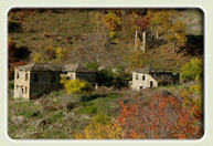 Because of their distinctive architecture and the unique way they have been incorporated into the natural environment, the
dozens of abandoned settlements in the area offer a great excuse for hiking. These are some indicative suggestions:
Because of their distinctive architecture and the unique way they have been incorporated into the natural environment, the
dozens of abandoned settlements in the area offer a great excuse for hiking. These are some indicative suggestions:
a) Kali Vrysi-Alevitsa peak (500m altitude difference,1.5 hours, marked)
b) Fousia ruins-Vertenik ruins (2 hours, marked)
c) Nea Kotyli-Palia Kotyli ruins (3 hours,
marked)
d) Pefkos village-Glykonerio ruins (2.5 hours) -
Peristera ruins (+2 hours), marked
e) Nestorio village-Kotyli (4 hours, marked)
|
|
|
|
 Ελληνική έκδοση Ελληνική έκδοση |
 see the map
|
|