|
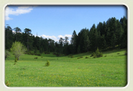
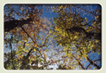
Mt. Gramos vegetation, forests and meadows

 Forests Forests |
The greatest part of Mt. Gramos is covered by dense forests. The landscape is completed by
meadows, thin forests and small farm lands. It is fairly easy to distinguish four basic zones: |
There are more that 487 different plant species in all these zones, a significantly large number for
one sole mountain and 21 of these are endemic which means that they can only be found on Mt.Gramos or the surrounding area.
|
|
|
- Riparian vegetation:
Alders, white willows and other trees form rich communities of dense
riverside vegetation, which often forms galleries. We also come across more rare trees as maple, linden and elm.
- Oak zone:
Various types of oaks are predominant above the streams forming brushwood or
forests, usually together with other deciduous trees.
- Black pine and beech zone:
The productive black pine forests start at approximately 1,000m and
higher up we have the beech forests (the area Arrenes is characteristic). We also come across firs in
some of the coolest and moist canyons. Bosnian pine (robola) the hardiest conifer in Pindos, thrives
in the higher altitudes.
- Forests become thinner and finally stop because the snow that covers the ground for many months
of the year, the cold and the wind prevent the development of even the hardiest trees. They are
replaced by alpine meadows, perhaps the largest, most characteristic and beautiful in the country.
Precious summer graze lands, these alpine meadows host at the same time small plants and
wildflowers, which are rare for Greek standards.
|
|
 |
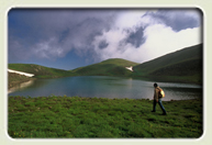
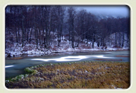
The alpine lakes and Aliakmon
Gistova and Moutsalia
|
Lake Gistova, the highest alpine lake in Greece at an altitude of
2,350 meters is situated in the alpine meadows of Gramos. Hidden
in a small niche among the tallest Gramos peaks, right on the
Albanian border line, Gistova retains its water year round and is a
rare habitat for Greek standards. A little further down, in the Epano
Arrena area at 1,730 meters we come across another twin lake, lakes
Moutsalia close to the forest line (upper forest line) in a landscape thickly covered with beech forests.
|
|
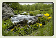
Aliakmon
The sources of Aliakmon, the longest Greek river, are in the Gramos
meadows. Dozens of springs feed with cold crystal water a labyrinth
of small brooks, which flow through the meadows until they
converge in the valley of Gramos. The river flows through the
Katafiki canyon where we find a cave used by the guerilla
fighters as a Hospital during the Civil war and passes by forests and
abandoned villages until it reaches the impressive Nestorio‘s valley with the vertical rocky cliffs.
|
|
|
|
|
|
 Ελληνική έκδοση Ελληνική έκδοση |
|