1.Nestorio –Glykoneri– Peuko– Lianotopi– Vertenik– Grammos return Grammos – Lianotopi– Trilofos– Monopylo- Giannochori– Livdotopi– Nestorio
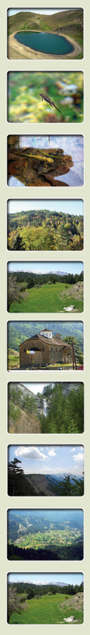
This route is approximately 82 Km long, requires a 4Χ4 vehicle and lasts from 2 to 3 hours depending on weather conditions. You may visit the above settlements and the mountain Grammos, which, with its highest peak at 2,520 meters, is the fourth highest mountain in Greece. Aliakmonas and Sarandaporos rivers have their sources in its slopes. Steep ravines, rocks, mixed forests, alpine lakes, dense vegetation and rare animal species (brown bear, fallow deer, wild pig, wolf, otter, chamois, - woodpecker , Golden eagle, Egyptian Vulture, and other species of the wild fauna), form the grandeur of the mountain that ranks amongst the most beautiful areas of Europe. At the sub-alpine zone of mountain Grammos, at the Greek-Albanian border the alpine lake Gkistova at 2,350m altitude is home to rare species of the Alpine Newt. We visit the lake and the mountain peak at 2,520m through a man-made pathway and only on foot. In this area you may enjoy the virgin forest Barouga, a mixed forest with European Beech, fir and black pine with open pastures, of significant ecological, scientific and aesthetic value, declared a “Monument of Nature”.
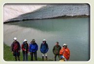
The largest part of this route is made along side the river Aliakmonas which is the longest river in Greece (310 km). At its source as well as along the river bed, there is a rare wetland habitat with 35 fish species, 215 bird species; including many protected species, as well as many mammals, reptiles and amphibians. In the areas close to the river banks, visitors may admire the rare natural wealth of the river or go fishing. Those who dare may try rafting or canoeing and kayaking in spring time. At the location Katafiki, visitors may see the unique canyon of Aliakmonas and, close to the exit, at a particularly wild area, they may see the great cave where the guerrillas had built a makeshift hospital during the Civil war.
In Trilofo (Slimnitsa), the deserted monastery of Saint George, the small church of Saint Christopher, as well as the churches of the Assumption of the Blessed Virgin (1743) in the upper district and of Saint Athanasios (1874) in the lower district. A faucet with a relief decoration is also noteworthy. In Peuko, it is worth visiting the monastery of Zoodoxos Pigi, built in beautiful scenery. In Giannochori, the church dedicated to the Assumption of the Blessed Virgin, the only one in the Balkans with a double women’s section, stands out for its elaborate wooden chancel. In Livadotopi, approximately 0.5 Km before entering the village you may see the beautiful waterfall.
2.Nestorio– Kotyli – Charos – National Reconciliation Park– Myrovlitis– Arenes– Aetomilitsa- return Arenes– Sgouros– Lianotopi– Virgin Mary Icon – Peukos– Nestorio
This route is approximately 115 Km long, requires a 4Χ4 vehicle and lasts from 4 to 5 hours depending on weather conditions.
While on this route - apart from the above settlements – you may also visit the following:
- Charos, the famous as well as impressive precipice standing at an altitude of approximately 300 meters. The view from this location is breath-taking. The surroundings were named after the heroic decision of a group of guerrillas to end their lives by jumping off the cliff instead of surrendering, during the Civil War.
- The settlement of Old Kotyli, panoramic view.
- The Fields of Kotyli, with the monument to the dead of the Civil War, as well as the National Reconciliation Park that was created in order to contribute to the cultivation of a spirit of understanding, co-operation and peaceful co-existence between the young men and women around the world. You may visit the modern facilities of the National Reconciliation Park.
After you pass over the bridge of Sarantaporos you will reach Arenes at an altitude of 1800 m, where you shall see the beautiful dragon lake Moutsalia, the only one in Greece where all three species of the Alpine Newt can be found. The lake is surrounded by an evergreen beech forest.
On the way back, in the area of Linotopi, you may visit the famous post-Byzantine monastery of Saint Zacharias decorated by the local icon painters, built in the woods, one of the most impressive monuments of the district. Built in the 16th century, the monastery is all what is left from a village named after the same Saint and destroyed by the Turks in 1769, during the “Orloff revolt”.
3. Nestorio– Peuko– Myrovlitis– Peukofyto– Chrysi– Eptachori- Zouzouli return Zouzouli– Eptachori– Kipseli– Kotyli– Nestorio
This route is approximately 135 Km long, requires a 4Χ4 vehicle (although the road is paved for half of the way) and lasts from 4 to 5 hours depending on weather conditions.
While on this route-apart from the above settlements – you may also visit the following:
- The fountainhead of Peukofyto
-
The stone bridges and watermills in Eptachori, Zouzouli and the old Kotyli.
- Throughout the route you shall enjoy forests with fir, pines, oak, cedar and beech trees, numerous ravines, wild rocky formations and steep slopes harmonically followed by valleys and plains, streams and rapid rivers.
You may also visit:
- Kastro (Castle), a natural acropolis east of Nestorio, at an altitude of more than 1000 meters. From ancient times to modern times, this location played an important role, protecting the area from raids. When you walk up to Kastro you will see the small church of the Holy Trinity.
- The Red Rock of Pegasus, at the entrance of Nestorio. According to the legend, the rock was coloured by the blood of the winged horse that fell from the sky, blinded by Zeus. Tradition has it that the cave at the base of the rock was once the nest of a fearful snake that protected the area.
- Saint Anna, 6 km away from Nestorio, place of the historical monastery of the Taxiarches of “Tsouka”, built around the 13th century and named after the homonymous deserted village, located at close distance towards the north. A unique specimen of the post-Byzantine architecture of stone-made structures, the monastery was characterised as a listed monument in 1961. It is built on a massive rock, over a confluent of Aliakmonas and a wonderful waterfall greatly resembling the region of Meteora.
- Ptelea, at a distance of 12 Km, where you shall admire the rare architecture of the Byzantine chapel of Saint Nikolas Petritis.
-Omorfoklissia, where you shall see the unique full-body relief of Saint George in the Church of Saint George.
- Dispilio, at a distance of 27 km. from Nestorio where you shall visit the eco-museum and the representation of the Limnaios Settlement of the Early Neolithic Period built around the lake.
-
Nostimo, 27 Km from Nestorio, where the Fossil Forest is located, estimated to be around 15-20 million years old, with tropical and sub-tropical flora, rare sea fossils and animal fossils. In the middle of the route you may visit Kastanofyto and the Folk Museum.
- In Korestia, in the village Melas, you may visit the house where Pavlos Melas was killed that functions as a museum with memorabilia of the Macedonian Struggle.
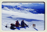
- Vitisi, 50 Km from Nestorio, where the Ski resort of Kastoria is open during winter with three tracks and one beginners’ track.
- And, of course, Kastoria, with the beautiful lake, the Byzantine and post-Byzantine monuments and its mansions. |
 |